
Written by Graduate Trainee, Christian Murray - Moon
Pendle Hill's dominating moorland habitat gives our landscape it's well-known appearance. The ambiguous characteristics (or lack thereof) that go along with this landscape, however, often make navigating by sight alone difficult. We have therefore installed a new series of stone way-markers on the hill to point our visitors in the right direction.
Although most areas of Pendle
Hill are open access land, meaning walkers have the right to roam freely, we
are hoping our new way markers will help people feel more confident when exploring
new areas as part of our 'access for all' project. We also hope that marking existing
paths will decrease the amount of disturbance people cause on the natural vegetation
and habitats, particularly as spring is upon us soon and so will be ground
nesting birds!
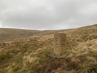
Image of a newly installed stone way-marker near the Nick of Pendle.
No task on Pendle Hill is without
its challenges though, and installing each of the four 160kg stones around the
hill has been no exception. But, with the help of local contractors Field &
Fell, installation was carried out professionally with skilful labour and a
can-do attitude, leaving each stone installed and quickly appearing as though
it already belongs in the landscape.
This well-blended appearance is
also helped by the golden-coloured sandstone material the way-markers are made
from. Sourced from within Lancashire, sandstone is naturally present throughout
Pendle Hill. The formation of this stone is evidence of remnant rivers which
dominated the area over 200 million years ago along with a warmer, tropical
climate which then existed, thanks to a closer positioning to the equator. Over
time, the sand these rivers once carried has since been deposited and compacted
by the weight of the land above to become stone. Millions of years in the
making, this sandstone has then be quarried, cut and engraved by local stone
masons of the Armstrong's group to help you on your way around Pendle Hill
today.
The first of our four stones is
positioned on the well-walked track from the Nick of Pendle to the summit where
this marker points, as well as to Mearley Moor. We hope this will encourage
people to visit the less-explored plateau for views towards the Forest of
Bowland peaks and North Yorkshire.
We have then
positioned three markers close to Ogden Clough, the scar-like valley which runs
through Pendle Hill from Barley where it is flooded with two reservoirs, to
just west of the summit. One of the markers here is located at the top end,
closest to the summit and at the end of the flagged path: pointing people on
their descent down Ogden Clough. The next stands at the top of the dizzyingly
steep path which leads out of the middle of the Clough and heads towards the
Nick, giving a reminder to anyone who needs it after being disorientated by the
Clough and climb. The last has been installed near Buttock at the lower, Barley
end of Ogden Clough. Here it marks the fastest path to Barley to those heading
down from the summit.

We hope that these way markers make it easier for you to find your way whilst out on the hill, although we still always recommend you take a map! If you see one up close on your travels, why not snap a shot and tag us on social media or upload it straight to our website to tell us where you're headed.